Tuesday, March 19, 2013

Are You Seeing Double? Bosch’s Laser Distance Meter Keeps Getting Better with the GLM80


Just when you thought you’ve seen them all…the Bosch GLM80 steps in. The Bosch GLM80 Laser Rangefinder is not just your typical handheld measuring device that reads distances and makes calculations. Don’t get me wrong – that’s a big part of this innovative digital tool, considering its 262-foot range and accuracy to ±1/16 inch. But, the Bosch GLM80 digital measurer is all that – and more. It brings new features to the world of digital laser measuring, such as a lithium-ion power source, rotating screen and probably most impressive of all – the ability to transform into a digital level using the included R60 Measuring Rail.


Let’s start with the GLM80’s dual role, then we’ll backtrack to the device itself.

Spring is almost here, Now is the time to prepare!


Grab a real bargain! - This best seller automatic level is now 30% Off!

Wednesday, March 13, 2013

The Secret Reason Why You're 40% Less Productive Than Your Surveying Competitors - And What To Do About It


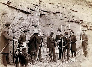
Old-fashioned surveying toolsThere's a secret to compiling nearly perfect measurements in very little time.

Every successful surveying company knows the secret, but many companies...well, they're clueless. Whipping through survey job after survey job, without hiring any extra staff - it's a kind of mystique that leaves you feeling like you've been left in the dust again by the Roadrunner.


Not any more.

Today I'm going to share with you that secret. The secret to banging out more than 400 points per day has less to do with being experienced or putting more men on the job - but it does depend on having one sneaky tool that weighs about as much as the average household cat...a robotic total station.

Sounds too easy, doesn't it?

Tuesday, March 12, 2013

Experience the Topcon Tesla Field Controller – Is Bigger Really Better?


It’s a challenge to stand out in the surveying and construction global market when most brands are equipped with the latest field innovations. Topcon, however, has done just that with their release of the largest screen data collector on the market! With their exclusive LongLink technology, wireless communication is possible with total stations up to 1000 feet away.

As one of the latest additions to the company’s comprehensive range of surveying field controllers, the Topcon Tesla is unique with its impressive 5.7-inch touchscreen display. The large screen offers better visibility and lets you view maps vertically or horizontally. It is also strategically placed in the perfect location for finger scrolling and accessing all graphical controls, allowing you to perform many screen functions with ease.
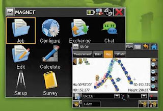
Topcon Tesla Windows InterfaceTopcon Tesla with Magnet Software

Mark your calendars for the celebration of National Surveyors Week, March 17-23, 2013.


National Surveyors Week is celebrated annually about the third week in March.This year that falls out on the week of March 17-23. GPS Day is held in conjunction with National Surveyors Week, and will be held on March 16 as a lead-in to the week. During that week, hundreds of surveyors nationwide are planning activities, like visits to schools and contacts with local media about the importance of the surveying profession.
 The practice of surveying goes back over three thousand years; that’s when the Egyptians first divided plots of land for the purpose of taxation.  Two hundred years later, the Greeks standardized procedures for surveying, incorporating the principles of geometry for precise demarcations and developing the first instrument used for surveying. In the 19th Century, surveying proved crucial for planning the infrastructure of the burgeoning countries. While plane surveying continued for smaller areas, for larger areas, surveyors started to apply geodetic principles to obtain a more accurate measure over larger areas. Instruments became more precise, as was required for planning roads, railroads, and canals.
  Today surveyors still meet the needs of property owners and developers, but they do much more, as well:
  • Hydrographic surveys are important to the use bodies of water;
  • Engineering surveys are utilized in the study and selection of engineering construction;
  • Geodetic surveys determine precise global positioning for such activities as aircraft and missile navigation;
  • Cartographic surveys are used for mapping and charting as well as photogrammetry, the science of using aerial photographs for measurement and map production.

In the National Society of Professional Surveyors press release, Curt Sumner, executive director of NSPS, notes, "there are over 45,000 professional surveyors in the United States. The value of their work remains vital to the future economic growth of our nation."  Without their professional skill to determine boundaries, the American dream of owning land would not be sustainable.  
 American surveyors include some very famous historical figures. The father of this country, George Washington, was a surveyor as a young man; he was one of the principals of the Ohio Company. Thomas Jefferson used a surveyor’s chain, “circumferentor” compass, and theodolite to survey land and elevations. Abraham Lincoln, worked as a surveyor, as well as a postmaster and storekeeper while studying law. Henry David Thoreau considered surveying as “a noble employment.” Walden Pond, which he immortalized in his famous book was also the subject of his surveying work. During the winter of 1846 Thoreau set up a grid on the frozen surface. At specific point, he bored through the ice to let down a weighted string to plumb the varying depths of the pond. 


Surveyors no longer have to clamber over ice to measure ponds.  Surveying equipment has grown high-tech with advanced instruments that work in conjunction with computations power for data collection, storage, retrieval, and sharing.  Satellites also come into play, as they are used to gather data on physical features that were previously beyond human reach.  One of the key pieces of equipment professional surveyors have grown to depend on is a Total Station.

Tiger Supplies always serves the needs of professional surveyors with the very latest equipment at the best prices.  Surveyors have the option of placing an order online from anywhere or dropping into the New Jersey showroom where they can see the range of instruments and accessories in the flesh.

As a special salute to the professionals honored during National Surveyor Week, Tiger Supplies is offering an unprecedented promotion: Buy the total station of your choice and get a starter kit valued at $695 as a gift. The free kit includes all those accessories you need to get started, like the prism, prism pole, and tripod. This is an exceptional value extended only for a limited time. Of course, Tiger Supplies always has the best prices on whatever you need for a surveying job.

Celebrate National Surveyors Week and celebrate savings at Tiger Supplies.


Monday, March 11, 2013

New and Exciting Updates to the Leica Disto Laser Distance Measuring Line on their 20 Year Anniversary!


Leica was the pioneer in designing, developing and releasing the first ever handheld laser distance measuring tool in 1993. Twenty years later, as a leader in construction laser tools, Leica has managed to stay ahead of the game by being the first to introduce new Apple, Android and Windows-integrated technology to their Disto laser distance measuring line.

Tiger Supplies has had a long relationship with Leica as an authorized dealer of their entire Disto line and many other Leica construction and surveying tools.The innovative technology that Leica now brings to the market is available for Leica’s indoor D330i, their top-of-the line and recently price reduced D8 and their brand new E7500i.

By downloading a Disto Transfer app and Disto Sketch app to your Android or Windows handheld device, your existing Bluetooth 2.1 enabled D330i and D8 laser distance meter can sync instantly with your tablet or smartphone.

Have an iPad, iPod Touch, or iPhone with Bluetooth 4.0?

Tuesday, March 5, 2013

Introducing the New Spectra T41 Data Collector – A Surveying Tool for the Modern Age


Spectra Precision, known for delivering quality products to the construction and surveying market, recently released the T41, a new handheld field computer that combines data collection with smartphone functionality. The high-portability and easy-to-use interface of this device makes it the ideal survey tool for professionals and even non-professionals looking for a more convenient method of data collection.

The new touch-screen handheld tool has a built-in GPS receiver, Bluetooth for transferring data wirelessly and connecting to other field equipment, Internet capabilities and your choice of Spectra Survey Pro data collection software. It also has an integrated 8-megapixel camera with flash and geotagging

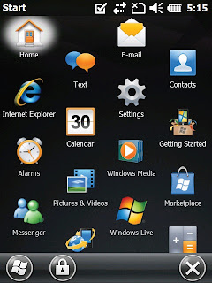
Keep in touch with your project manager and clients outside the office with the SMS and call capabilities of the Spectra T41 Data Collector. This convenient handheld device is a topographic field computer and a smartphone in one! It also runs your favorite Microsoft programs wherever you go with Windows Embedded Handheld 6.5 operating system. With this portable field controller, you can use mobile versions of Internet Explorer and Microsoft Office 2010 applications such as Word, PowerPoint, Outlook and Excel. 
Weighing less than 1 pound and operating up to 14 hours, you can carry this mobile data collector wherever your survey project takes you. Its impressive IP-65 rating will protect your valuable field data even in the harshest weather conditions. In addition, its touchscreen display is protected by Gorilla Glass and can be viewed easily in bright sunlight. 

Tiger Supplies is the popular destination online for people in search of Total Stations, Theodolites, Electronic Levels, Pipe Laser, Rotary Lasers, Laser Distance Measure, and other supplies and equipment dedicated to the surveying, construction, architectural and engineering fields. The company is committed to delivering quality service to their valued customers with their highly-trained professional staff. As an authorized dealer of Spectra Precision products and other major brands of land surveying equipment, customers can get discounts up to 30% off regular retail prices! 

Eliminate the hassle of carrying multiple devices; the Spectra T41 Data Collector, available now on Tigersupplies.com combines all the functionality needed to optimize workflow in any construction or survey project. We are confident that the features integrated within this surveying instrument will simplify field data recording.


Further Reading:
Spectra Precision Introduces New and Updated Products 


Leica Introduces Next Generation Disto to its Product Line. Keeping up with the Times.

Leica Disto E7500i
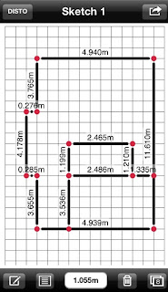
With all the amazing innovative products Leica has come out with over the last 20 years, you’re probably wondering, how can they top themselves? Well, they just did. Today, Leica introduced a new laser distance meter to their already extensive Disto line of products. The new and exciting breakthrough technology of the E7500i is the first of its kind to communicate with Apple-brand products. Using Bluetooth Smart 4.0, the E7500i laser distance measurer can connect to the new 3rd-generation iPad, iPad mini, iPhone 4S, 5 and iPod Touch. In conjunction with a free Leica Disto sketch app, you can instantly photograph, sketch and input precise dimensions right on your Apple device!


     Following are 5 steps to using this app in conjunction with your Disto:

  • Obtain your measurements using the laser for indoor use or the digital Pointfinder with 4x zoom for outdoor use
  • Take a picture of your target, or create a floor plan on a grid map. Both instantly appear on your Apple device
  • Use the touch screen to draw line segments anywhere on the screen
  • Drag your measurements that are already saved on your Apple device to any point on the screen
  • Save your results for further calculation or send via email. It’s that easy!
Leica Sketch App for Disto E7500i

The Disto E7500i still incorporates all of your favorite functions and features that you come to expect from Leica, such as a durable and rugged water-resistant and dust-proof design, a full color outdoor touch-screen display, up to 5,000 measurements on a single set of batteries, 360-degree tilt sensor, 1/16 inch accuracy, 650-foot range and much more. Some new features of this laser distance meter are the “hot keys” – two customizable shortcut keys for your most commonly used functions and an integrated help menu.  In addition, the handheld device uses a modern interface specifically created to mimic the easy and intuitive design of smartphones. The E7500i is also the world’s first and only laser distance meter to conform to a new ISO industry standard for accuracy and range (ISO 16331-1). All of this comes with a 3-year warranty when you register your product online.

With all of these amazing features, it’s a wonder that the E7500i is still small enough to fit in your pocket. Tiger Supplies is an authorized dealer of Leica products and one of the first to offer this new distance meter for sale. Not only that, but we are offering free overnight shipping and free red laser glasses! To purchase, or for more information about the E7500i and to view a detailed video about the innovative Leica Sketch app, visit our website at www.tigersupplies.com We also have a full-line of accessories for handheld distance lasers.

Monday, March 4, 2013

Why Every Total Station Needs a Right-hand Man. The Ideal Surveying Accessory.


Land surveying techniques have been around since almost the beginning of recorded history. As a matter of fact, it can be traced back to as early as 3000 BC in ancient Egypt after the Nile River overflowed and farm boundaries were re-established using simple geometry. Surveying technology has come a long way since then and living in a modern civilization requires a more sophisticated and accurate method of collecting field data in order to build advanced and safe structures such as highways, railroads, skyscrapers, large irrigation projects and power plants. This requirement is filled through the use of data collectors, otherwise known as surveying detectors or receivers.

The land surveying equipment used today is a far cry from the ones used by surveyors’ decades ago. Electronic data collectors are now widely used to record precise measurements of coordinates, angles, distances, elevations and more. This battery powered handheld field computer with LCD touchscreen display and user friendly on-board data collection software takes the place of a tape measure, smartphone and other basic surveying equipment in gathering field data, all in the palm of your hand.